Best time to go to Panama for a perfect weather and where to go?
When is the best time to go to Panama?
The best time to visit Panama extends from December to April, which corresponds to the dry season. During this time of the year, the heat is on, and even if showers occur, they quickly dissipate. The rest of the day is often sunny and allows for cultural discoveries, relaxation, diving with excellent visibility, or embarking on a hike in the heart of nature.
Also known as "verano" (summer) by Panamanians, this season offers the opportunity to explore the entire country without weather constraints. The downside: it is the peak tourist season in Panama. Prices may reflect this, but more importantly, the nicest hotels quickly fill up, especially in December, which is the most popular month of the year. We therefore recommend making your reservations as early as possible to have more choices and enjoy a relaxing stay!
From May to November, it is "invierno," which of course has nothing to do with the European or North American winter. This period corresponds to the rainy season, which is particularly pronounced in the central part of the country as it lingers until December. As the name suggests, rain is a daily occurrence. However, a trip during this time of the year is not to be ruled out and even offers magnificent compensations.
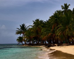
Indeed, it is during the rainy season, between July and October, that humpback whales are present along the coasts. They arrive there after a journey of over 5 months from the northern hemisphere to give birth in warm waters. You can observe this giant nursery along the entire southern coast, especially on the splendid island of Taboga, 20 km south of Panama City.
Also during the rainy season, it is possible to witness the nesting of leatherback turtles on the beaches of the Caribbean coast. Another advantage: tourist traffic is relatively lower compared to the dry season, so you can enjoy your stay away from the crowds.
When to visit Panama? In summary, if you are a wildlife enthusiast, the wet season between July and October is ideal, and the showers will be just a detail, given how awe-inspiring the spectacle of nature is. On the other hand, if good weather conditions are essential for your vacation, opt for the dry season between December and April.
Where and when to go based on the weather?
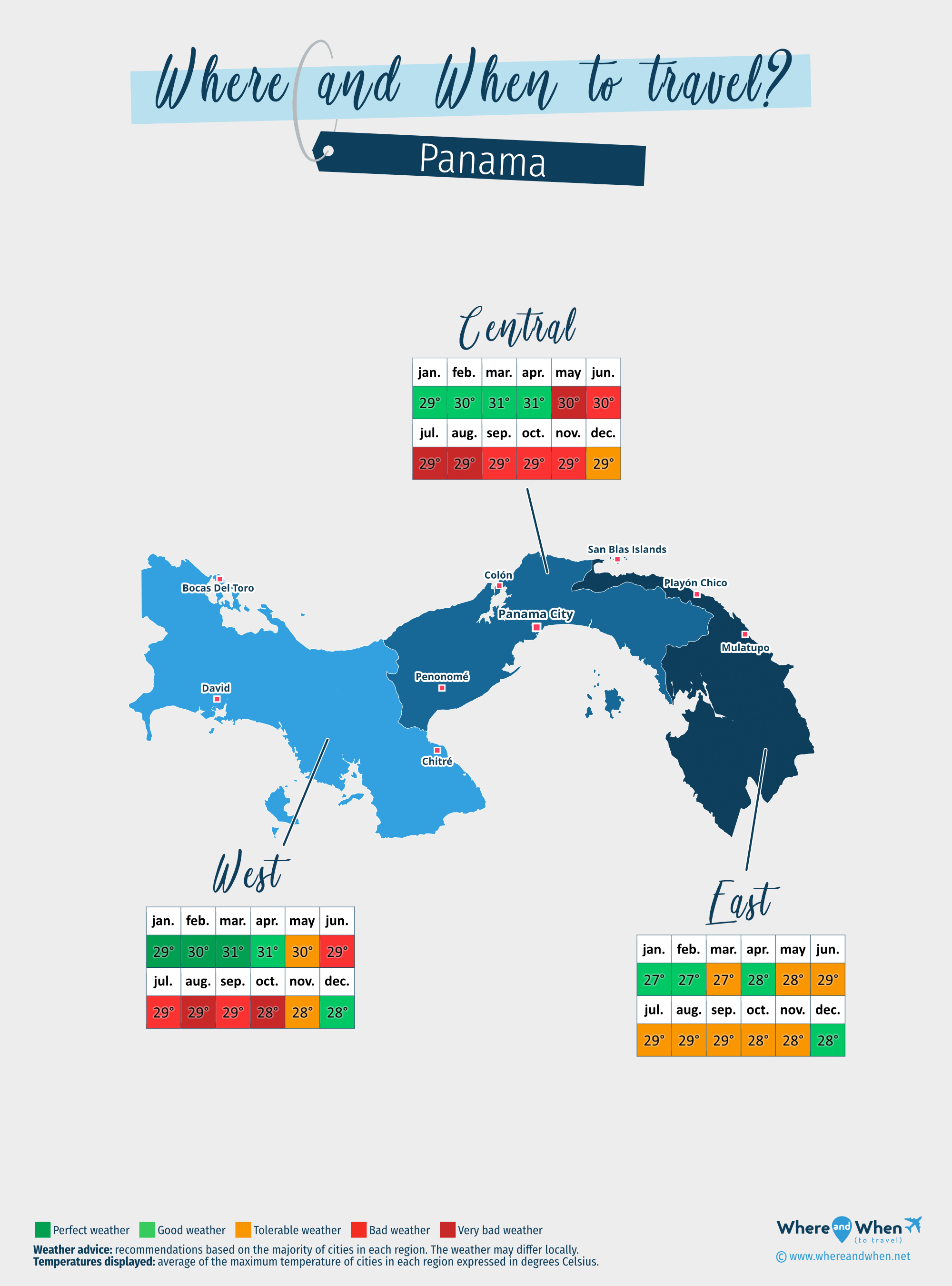
Central of Panama
Panama City, Penonomé, Colón...
East of Panama
San Blas Islands, Playón Chico, Mulatupo...
West of Panama
Bocas Del Toro, David, Chitré...
To get all the information about the climate and weather in Panama for a specific month, click on the corresponding link below:
Panama in january Panama in february Panama in march Panama in april Panama in may Panama in june Panama in july Panama in august Panama in september Panama in october Panama in november Panama in december
Best time to travel to Panama by cities


Climate and Weather in Panama
Located between Costa Rica and Colombia, in the heart of Central America, the country has two maritime openings: on the Caribbean Sea and on the Pacific Ocean, as well as a mountain range that crosses it from one end to the other.
The climate of Panama is tropical, with three variations depending on the regions:
- An equatorial climate with abundant rainfall and a constant temperature throughout the year. This is found in the entire region located to the west of the country, bordering Costa Rica, but also in parts of the center, especially towards Anton.
- A tropical monsoon climate is present in the capital, Panama City, throughout the central zone of the country, as well as in the Mulatupo region to the east.
- A tropical savanna climate with a dry winter prevails mainly in the east, from the San Blas islands to the Colombian border.
In general, there are indeed half as many precipitations on the Pacific coast as on the Caribbean coast, with the central mountain range of the country naturally protecting the lowlands from rain. Furthermore, the weather in Panama is characterized by a small thermal amplitude over the months (rarely more than a 3°C (38°F) difference throughout the year, with averages ranging between 27 and 31°C (88°F) depending on the regions). This is due to its proximity to the equator, just like the two seasons experienced in the country:
- The dry season, from December to April, enjoys a fairly stable climate: the humidity level in the air is reasonable and the temperatures are warm without being stifling. During this period, it still rains regularly, but showers mostly occur in the late afternoon and never last long.
- The rainy season, from May to December, is marked by more changeable weather: it can be sunny and within 5 minutes, a curtain of rain falls. Most of the time, mornings are sunny, so it's best to prioritize activities during that time. Tropical showers are almost daily in the afternoon, followed by the return of the sun in the early evening. Particularly intense thunderstorms can occur, but Panama remains outside cyclonic corridors. If the combination of humidity and heat becomes overwhelming, don't hesitate to head to higher altitudes where the atmosphere is always pleasant.

Climate in Eastern Panama
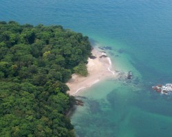
The Eastern part of Panama is the least humid in the country, and the climate there is more favorable than elsewhere, especially around the San Blas Islands and El Porvenir. Further south along the Caribbean coast, towards Playón Chico or Mulatupo, the weather is rainier, mainly due to the north and northeast winds bringing precipitation.
Temperatures in this area of Panama are also cooler than in other regions. Expect 27°C (81°F) between January and March, 29°C (85°F) from June to September, and 28°C (83°F) during the transitional seasons.
The best time to visit is from early December to late April, but if you plan a trip during the rainy season, opt for a stay along the Pacific coast, where the atmosphere is drier.
Climate in Central Panama
The weather in central Panama is ideal between January and April. Unlike the east of the country, the northern part along the Caribbean coast receives less rain during the rainy season than the southern coast on the Pacific side. During this period, it is better to go to Colón than to the islands in the Gulf of Panama, such as Taboga or Contadora.
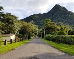
Very mountainous, the inland areas have a more temperate climate than the coasts, except for the Central Valley, where the city of Gamboa has temperatures similar to those of Panama City. Expect 29°C (85°F) in November and 31°C (88°F) between February and April, approaching the rainy season.
Climate in Western Panama
During the dry season, from December to April, the west of the country experiences high temperatures, regularly exceeding 30°C (86°F) and even reaching around 35°C (95°F) in places like David, Chitré, or Sona. To cool off, head to Bocas Del Toro, Chiriqui, or even better, Boquete. In this mountainous area, the climate is particularly mild with temperatures ranging between 25 and 28°C (83°F) .
During the rainy season, from May to November, temperatures drop only 1°C (34°F) , but humidity levels are high due to abundant and regular rainfall, especially on the southern coast towards Los Santos.
Temperatures and rainfall in Panama
On these 3 graphs, we present the evolution of temperatures of Panama and month-by-month rainfall for the cities of Panama City, Bocas Del Toro, Chitré, Colón and David, as well as the month-by-month sea temperature for coastal cities.

Peak visitor numbers and tourist seasons in Panama
Find out when Panama has its high tourist season (the period when the influx of tourists is highest) and off-peak tourist season using our data and figures.
Tourist seasons in Panama
The months with low numbers of tourists are: April, May, June, July, September and October. The number of visitors to Panama is high in: January, February, March, August, November and December.
- Very low season in Panama: May, June, September and October.
- Low season in Panama: April and July.
- High season in Panama: January, February, March, August and November.
- Peak season in Panama: December.
Figure: Visitor index for Panama month by month
Average price for flights to Panama
A return flight between Montreal and Panama City is generally cheaper if you go in october ($ 602 on average): this is the best time for travellers on a tight budget. In contrast, you may end up paying $ 328 more for your airline ticket to Panama City if you go in december.
Where to go in Panama?
This table allows you to see the maximum temperature for each city and our opinion on the weather month by month (see colour legend below the table).
| Cities | jan. | feb. | mar. | apr. | may | jun. | jul. | aug. | sep. | oct. | nov. | dec. |
| Panama City | 86°F | 88°F | 88°F | 88°F | 86°F | 86°F | 86°F | 86°F | 86°F | 86°F | 85°F | 86°F |
| Bocas Del Toro | 81°F | 83°F | 83°F | 85°F | 85°F | 85°F | 85°F | 85°F | 86°F | 85°F | 85°F | 83°F |
| Chitré | 88°F | 88°F | 90°F | 90°F | 88°F | 86°F | 86°F | 86°F | 86°F | 86°F | 85°F | 86°F |
| Colón | 85°F | 85°F | 85°F | 85°F | 86°F | 85°F | 85°F | 85°F | 86°F | 85°F | 85°F | 83°F |
| David | 88°F | 92°F | 94°F | 92°F | 90°F | 88°F | 86°F | 86°F | 86°F | 85°F | 86°F | 86°F |
| Mulatupo | 83°F | 83°F | 83°F | 85°F | 85°F | 86°F | 86°F | 86°F | 86°F | 85°F | 85°F | 85°F |
| Penonomé | 88°F | 90°F | 92°F | 92°F | 88°F | 88°F | 86°F | 86°F | 86°F | 86°F | 86°F | 86°F |
| Playón Chico | 83°F | 83°F | 83°F | 85°F | 85°F | 86°F | 86°F | 86°F | 86°F | 85°F | 83°F | 83°F |
| San Blas Islands | 81°F | 81°F | 81°F | 83°F | 83°F | 85°F | 83°F | 83°F | 85°F | 85°F | 83°F | 83°F |
| Anton | 88°F | 88°F | 90°F | 90°F | 88°F | 86°F | 86°F | 86°F | 86°F | 86°F | 85°F | 86°F |
| Boquete | 77°F | 79°F | 81°F | 83°F | 79°F | 79°F | 79°F | 79°F | 79°F | 77°F | 77°F | 77°F |
| Contadora island | 85°F | 86°F | 88°F | 88°F | 86°F | 86°F | 86°F | 86°F | 86°F | 85°F | 85°F | 85°F |
| El Porvenir | 81°F | 81°F | 81°F | 83°F | 83°F | 85°F | 83°F | 83°F | 85°F | 85°F | 83°F | 83°F |
| Gamboa | 86°F | 88°F | 88°F | 88°F | 86°F | 86°F | 86°F | 86°F | 86°F | 86°F | 85°F | 86°F |
| Hicacos Peninsula | 86°F | 86°F | 88°F | 88°F | 86°F | 86°F | 85°F | 85°F | 86°F | 85°F | 85°F | 85°F |
| Los Santos (Las Tablas) | 88°F | 88°F | 90°F | 90°F | 88°F | 86°F | 86°F | 86°F | 86°F | 86°F | 85°F | 86°F |
| Taboga island | 86°F | 86°F | 88°F | 88°F | 86°F | 86°F | 85°F | 85°F | 86°F | 85°F | 85°F | 85°F |
| Aguadulce | 88°F | 90°F | 92°F | 92°F | 88°F | 88°F | 86°F | 86°F | 86°F | 86°F | 86°F | 86°F |
| Arraijan | 86°F | 86°F | 88°F | 88°F | 86°F | 86°F | 85°F | 85°F | 86°F | 85°F | 85°F | 85°F |
| Buabidi | 83°F | 86°F | 88°F | 90°F | 88°F | 86°F | 86°F | 86°F | 85°F | 81°F | 81°F | 83°F |
Legend:
perfect weather
good weather
tolerable weather
bad weather
very bad weather
About Panama
What can I do in Panama?
Beaches / swimming
Nature and countryside
Culture and heritage
Sports
Family travel
Crafts / shopping
Gastronomy
Nightlife
Is this weather information for Panama reliable?
Climate data for Panama has been gathered every day since January 2009. The analysis of these meteorological data for Panama allows us to determine the average for each month in Panama City, Bocas Del Toro, Chitré, Colón, David, Mulatupo, Penonomé, Playón Chico, and 19 other cities.
So yes: this data is reliable except in cases of temporary climate disruption in the region.