Best time to go to Colombia for a perfect weather and where to go?
When is the best time to go to Colombia?
The best time to travel to Colombia is during the winter, between December and the end of March. Depending on the regions, there is also a pleasant little dry season in July and August.
However, the rest of the year should not be ruled out: as the country is very vast, there is always a region spared from the rains between April and November. Moreover, the climate is rarely extreme, with a few exceptions, especially if you plan to visit high altitudes (over 3000 m.).
Therefore, the only region to avoid during the local rainy season is the Amazon. The humidity rate is very high there (close to 100%) and your trip to Colombia could be reduced to uninterrupted days of rain.
When to go to Colombia based on your interests?
- For hiking and trekking, the months of January to March offer exceptional weather. The sun shines, but the heat remains reasonable.
- For diving, the ideal period extends from January to April. The visibility is perfect and the water temperature very pleasant.
- For relaxing and enjoying the beach, the Caribbean coast is perfect between December and the end of April.
- To discover the wonders of the Amazon, it is best to go to Colombia between July and October.
- To observe humpback whales, head to the Pacific coast between July and September. They will offer you an unforgettable show!
- To see cultural events, mingle with the joyful crowd during the dry season. At the end of February, do not miss the Barranquilla Carnival, which ranks just after the one in Rio de Janeiro, Brazil, in terms of animation and popularity.
Where and when to go based on the weather?
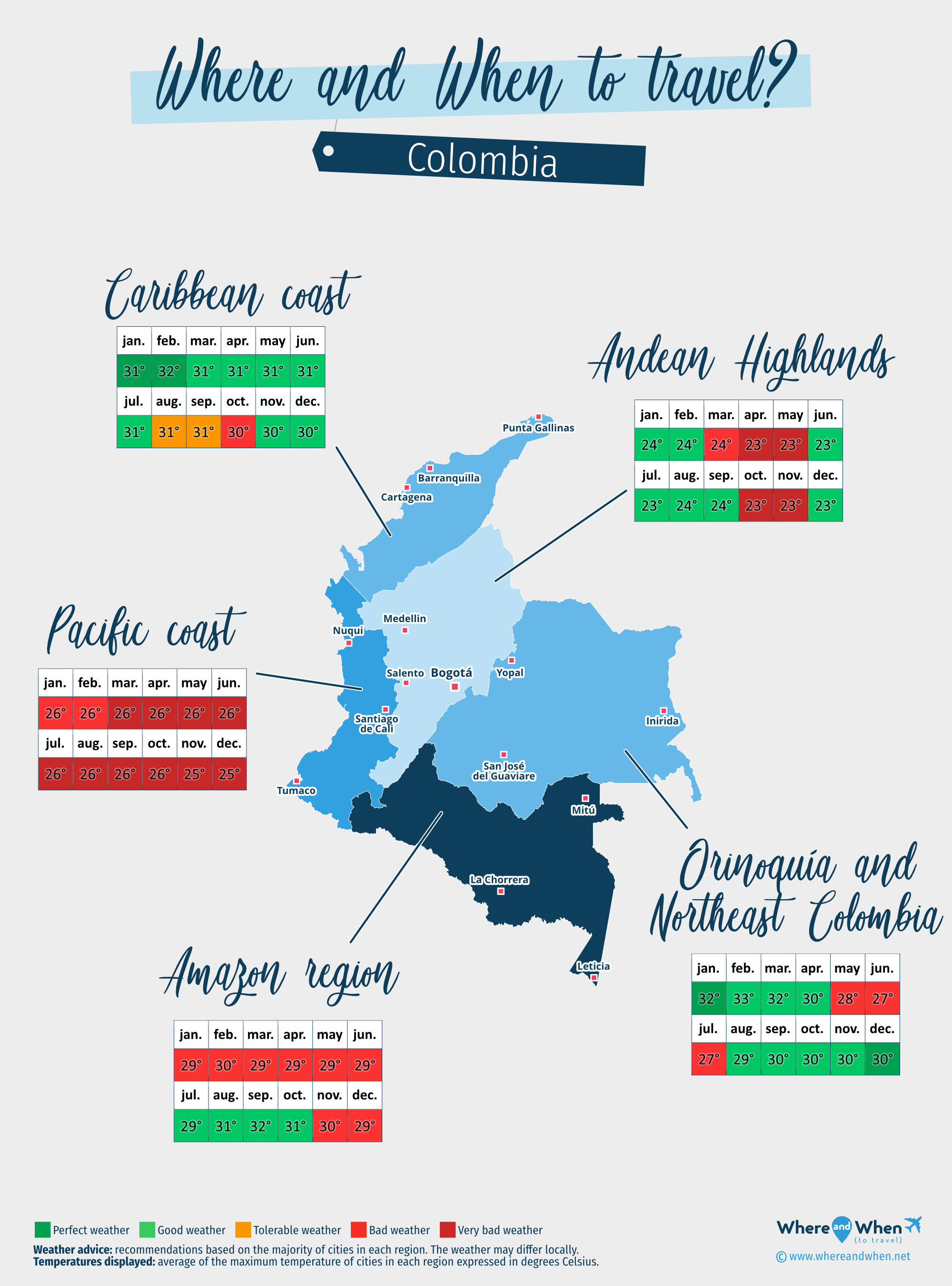
Amazon region of Colombia
Leticia, San José del Guaviare, Inirida...
Andean Highlands
Bogota, Medellin, Bucaramanga...
Caribbean coast of Colombia
Cartagena, Barranquilla, Cabo de La Vela...
Orinoquía
Caño Cristales, Yopal, Villavicencio...
Pacific coast of Colombia
Tumaco, Buenaventura (Valle del Cauca), Mutis (Bahía Solano)...
To get all the information about the climate and weather in Columbia for a specific month, click on the corresponding link below:
Colombia in january Colombia in february Colombia in march Colombia in april Colombia in may Colombia in june Colombia in july Colombia in august Colombia in september Colombia in october Colombia in november Colombia in december
Best time to travel to Colombia by cities


Climate and Weather in Columbia
Located in South America, between Venezuela, Brazil, Panama, and Peru, Colombia's climate is tropical due to its proximity to the equator.
There are two main seasons and transitional periods:
- Summer (verano), which corresponds to the rainy season and lasts from June to October.
- Winter (inverno) which goes from December to the end of March.
- The transition months are therefore April, May, and November.
Due to its geography, Colombia's weather can vary greatly depending on the region and altitude. However, temperatures remain relatively stable. It is mainly the humidity and frequency of rainfall that can vary.

Climate around Bogotá and in the Andean regions
The capital of Colombia is located in the heart of the eastern Andes mountain range. In this region, the climate is described as "highland temperate", meaning that temperatures during midday hover around 17°C throughout the year and rarely exceed 20°C.
In general, the higher the altitude, the colder it gets (an average decrease of 6°C every 1000 meters). Thus, the city of Medellín, located at a lower altitude, enjoys milder temperatures. However, it receives more rainfall than the capital.
It is worth noting that during the season, rainfall is quite significant. Rain showers occur in the region from September to December and from April to June. The sky remains mostly overcast throughout the year due to the high surrounding mountains.
Climate in the Amazon
The Colombian Amazon regions experience distinct seasons. The climate is tropical with variations compared to the rest of the country:
- Dry season between July and October: this is the ideal time to visit. The weather is pleasant, despite high temperatures, and precipitation is less than the rest of the year.
- Rainy season between January and June. It is advisable to avoid this period due to heavy rainfall. Hiking trails become very muddy and impassable.
Climate in central Colombia and the Coffee Triangle
Also crossed by the eastern Andes mountain range, the Boyaca region in the country's center, as well as the neighboring Coffee Triangle, experience all types of temperatures. In the valleys, temperatures can easily exceed 35°C, while at higher altitudes, they drop significantly and can sometimes fall below 0°C.
Climate of the Caribbean coast
In northern Colombia, the Caribbean coast stretches over 1600 km. Rich in splendid beaches and colorful colonial cities, it is a highly popular region among travelers. Regarding the climate, here is what to expect:
- During the dry season between December and April, the weather is ideal: clear skies and low precipitation.
- Temperatures remain relatively constant throughout the year.
- The rainy season is not very pronounced in this region. Therefore, a stay in June and October is entirely feasible.
- From July to late September, although the sky clears up, humidity levels are very high, making the atmosphere stifling.
- In the islands off the Caribbean coast, such as San Andrés or Providencia, the trade winds make the air more breathable, and the rainy season is shifted between October and December.
Climate on the Pacific coast
Be warned: the entire Pacific coast of Colombia is considered one of the wettest areas on the planet! The temperature remains relatively stable throughout the year, ranging between 23°C and 29°C, but precipitation is significant. However, it rarely rains all day: most of the time, the coast is showered mainly in the evening and at night, even during the rainy season.
Temperatures and rainfall in Columbia
On these 3 graphs, we present the evolution of temperatures of Colombia and month-by-month rainfall for the cities of Bogota, Cartagena, Medellin, Barranquilla and Bucaramanga, as well as the month-by-month sea temperature for coastal cities.
Peak visitor numbers and tourist seasons in Columbia
Find out when Colombia has its high tourist season (the period when the influx of tourists is highest) and off-peak tourist season using our data and figures.
Tourist seasons in Columbia
The months with low numbers of tourists are: January, February, March, April, May, June, July, September, October and November. The number of visitors to Colombia is high in: August and December.
- Very low season in Columbia: February, March, April, May, June, September and October.
- Low season in Columbia: January, July and November.
- Peak season in Columbia: August and December.
Figure: Visitor index for Colombia month by month
Average price for flights to Colombia
A return flight between New York City and Bogota is generally cheaper if you go in may ($ 428 on average): this is the best time for travellers on a tight budget. In contrast, you may end up paying $ 206 more for your airline ticket to Bogota if you go in december.
Find the best price for your flight Flight prices to Colombia
Where to go in Columbia?
This table allows you to see the maximum temperature for each city and our opinion on the weather month by month (see colour legend below the table).
| Cities | jan. | feb. | mar. | apr. | may | jun. | jul. | aug. | sep. | oct. | nov. | dec. |
| Bogota | 70°F | 68°F | 68°F | 67°F | 67°F | 67°F | 67°F | 68°F | 70°F | 68°F | 67°F | 68°F |
| Cartagena | 88°F | 90°F | 88°F | 88°F | 88°F | 90°F | 90°F | 88°F | 88°F | 86°F | 88°F | 88°F |
| Medellin | 79°F | 79°F | 77°F | 76°F | 77°F | 79°F | 79°F | 81°F | 79°F | 76°F | 76°F | 77°F |
| Barranquilla | 88°F | 88°F | 88°F | 90°F | 90°F | 90°F | 90°F | 90°F | 90°F | 88°F | 88°F | 88°F |
| Bucaramanga | 77°F | 81°F | 81°F | 79°F | 79°F | 79°F | 79°F | 79°F | 79°F | 77°F | 76°F | 76°F |
| Buenaventura (Valle del Cauca) | 85°F | 86°F | 86°F | 86°F | 85°F | 85°F | 85°F | 85°F | 85°F | 85°F | 83°F | 85°F |
| Cabo de La Vela | 88°F | 90°F | 90°F | 92°F | 92°F | 92°F | 92°F | 94°F | 94°F | 92°F | 90°F | 88°F |
| Caño Cristales | 88°F | 90°F | 86°F | 85°F | 83°F | 81°F | 81°F | 85°F | 88°F | 86°F | 86°F | 86°F |
| Inirida (Cerros de Mavecure) | 92°F | 95°F | 92°F | 86°F | 85°F | 83°F | 83°F | 85°F | 88°F | 88°F | 88°F | 88°F |
| Leticia | 86°F | 88°F | 86°F | 86°F | 86°F | 88°F | 90°F | 94°F | 95°F | 94°F | 90°F | 88°F |
| Mutis (Bahía Solano) | 86°F | 86°F | 86°F | 85°F | 83°F | 83°F | 83°F | 83°F | 85°F | 83°F | 83°F | 85°F |
| San José del Guaviare | 88°F | 90°F | 86°F | 85°F | 83°F | 81°F | 81°F | 85°F | 88°F | 86°F | 86°F | 86°F |
| Tumaco | 83°F | 83°F | 83°F | 85°F | 85°F | 83°F | 83°F | 83°F | 83°F | 83°F | 83°F | 83°F |
| Villavicencio | 86°F | 86°F | 85°F | 83°F | 81°F | 79°F | 79°F | 83°F | 85°F | 85°F | 83°F | 83°F |
| Yopal | 90°F | 92°F | 90°F | 86°F | 85°F | 83°F | 81°F | 85°F | 88°F | 86°F | 86°F | 88°F |
| Amacayacu Natural National Park | 86°F | 88°F | 88°F | 86°F | 86°F | 86°F | 88°F | 92°F | 94°F | 92°F | 90°F | 88°F |
| Arboletes | 94°F | 95°F | 94°F | 92°F | 92°F | 92°F | 92°F | 92°F | 90°F | 90°F | 90°F | 90°F |
| Armenia | 72°F | 74°F | 72°F | 70°F | 70°F | 72°F | 74°F | 76°F | 74°F | 70°F | 68°F | 70°F |
| Barú | 88°F | 90°F | 88°F | 88°F | 88°F | 90°F | 90°F | 88°F | 88°F | 86°F | 88°F | 88°F |
| Bocas de Aracataca | 85°F | 86°F | 86°F | 86°F | 85°F | 83°F | 83°F | 83°F | 83°F | 83°F | 83°F | 85°F |
Legend:
perfect weather
good weather
tolerable weather
bad weather
very bad weather
About Colombia
What can I do in Columbia?
Beaches / swimming
Nature and countryside
Culture and heritage
Sports
Family travel
Crafts / shopping
Gastronomy
Nightlife
Is this weather information for Colombia reliable?
Climate data for Colombia has been gathered every day since January 2009. The analysis of these meteorological data for Colombia allows us to determine the average for each month in Bogota, Cartagena, Medellin, Barranquilla, Bucaramanga, Buenaventura (Valle del Cauca), Cabo de La Vela, Caño Cristales, and 91 other cities.
So yes: this data is reliable except in cases of temporary climate disruption in the region.