Best time to go to Guatemala for a perfect weather and where to go?
When is the best time to go to Guatemala?
The best time to visit Guatemala is from November to May, during the dry season. The weather is then perfect: humidity is very low, temperatures are pleasant in tropical areas, and the brightness is perfect in the volcanic region. You can enjoy beautiful beaches and water activities, discover ancient Mayan cities, go on unforgettable hikes, and attend various cultural events.
From mid-December to May, nature lovers can head to the Pacific coast to observe humpback whales that migrate along the coast, a breathtaking sight not to be missed!
If you have no choice but to travel during the peak vacation months of July and August, opt for Petén and coastal areas: either on the Caribbean coast or, better yet, on the Pacific coast. It is best to avoid the mountainous areas in the west and center, which are very rainy and cold at higher altitudes. However, this period corresponds to the high tourist season in Guatemala. Airfare prices soar, and hotels and guesthouses quickly fill up. We recommend booking as early as possible.
When to go to Guatemala? If you want to explore all regions of the country, the months of February and March are ideal, as the weather conditions are perfect everywhere and the crowds are reasonable.
What to pack? It depends on the time of year you are traveling, the activities you plan to do, and the regions you will visit:
- If there is a risk of rain, during the shoulder seasons or the rainy season, bring a waterproof garment to protect yourself from tropical downpours.
- In forested areas, long pants and sleeves are essential to avoid mosquito bites. Also, remember to bring an effective insect repellent.
- If you want to visit archaeological sites and go hiking, choose good non-slip walking shoes.
- In the highlands, it can freeze at night, and there is no heating: bring warm clothing.
- Bring sun protection: a hat or cap, sunglasses, and sunscreen that meets European standards.
- For safety reasons, do not bring any valuable jewelry.
Where and when to go based on the weather?
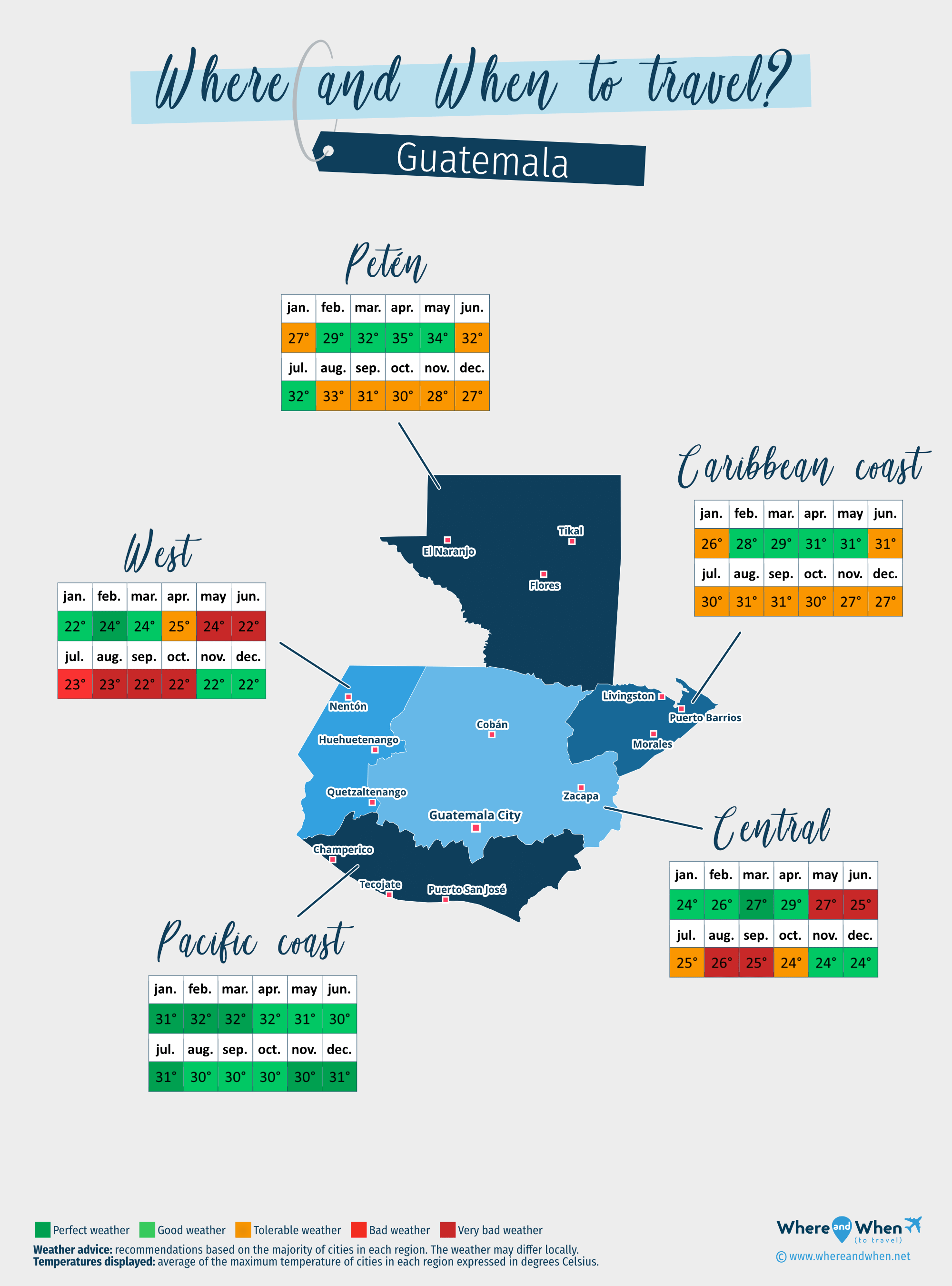
Caribbean coast of Guatemala
Livingston, Puerto Barrios, Morales...
Central of Guatemala
Guatemala City, Cobán, Zacapa...
Pacific coast of Guatemala
Champerico, Puerto San José, Tecojate...
Petén
Flores, El Naranjo, Tikal...
West of Guatemala
Huehuetenango, Quetzaltenango, Nentón...
To get all the information about the climate and weather in Guatemala for a specific month, click on the corresponding link below:
Guatemala in january Guatemala in february Guatemala in march Guatemala in april Guatemala in may Guatemala in june Guatemala in july Guatemala in august Guatemala in september Guatemala in october Guatemala in november Guatemala in december
Best time to travel to Guatemala by cities

Climate and Weather in Guatemala
Guatemala is a country in Central America bordered by the Caribbean Sea to the east and the Pacific Ocean to the west. It is located south of Mexico, west of Belize, and north of Honduras and El Salvador.
The climate of Guatemala has three different types:
- A tropical savanna climate with a dry winter throughout the southern zone, parts of the central region, in Zacapa and Quetzaltenango, and in western Petén, near El Naranjo. This is the most common climate type, covering 54% of the country.
- A tropical monsoon climate on the Caribbean coast.
- A subtropical highland climate with a dry winter and a temperate summer prevailing in the capital and on the central highlands.
In general, the temperature range is low, temperatures are rather high throughout the year, although they are milder in the central mountains, and Guatemala has two seasons:
- A rainy season that lasts from May to October: the atmosphere is then humid and showers can be intense, especially in the west and center of the country. Elsewhere, it is more about brief showers and the sun is often shining. It should also be noted that during this season, the Caribbean coast is susceptible to cyclones.
- A dry season that starts in early November and ends in late April or late May depending on the regions. Precipitation is low, or even non-existent, on almost the entire territory, except on the Caribbean coast where they are more significant but still moderate. The weather in Guatemala is pleasant everywhere during this period, making it the best time to plan a trip.

Climate in central Guatemala
The center of the country is mainly composed of high plateaus. This is where the largest cities are located, such as the capital Guatemala City, and where the majority of the population is concentrated.
The climate is mainly subtropical highland, with dry winters and temperate summers. Some areas have a more tropical climate, either savannah with a dry winter or monsoon, as they are not at high altitudes. This is the case, for example, around Zacapa or Lanquín.
Temperatures range from 20 to 24°C at night, and between 29 and 34°C during the day, with April being the hottest month of the year. Overall, it is always colder in the highlands than in the plains: in the mountains above 2000m altitude, it is not uncommon to see temperatures close to 0°C. In addition, the temperature difference between day and night is considerable.
The entire region receives a lot of rainfall during the rainy season, however, showers mostly occur in the afternoon and evening. It is therefore entirely possible to plan early morning outings during this period.
Climate on the Caribbean coast
The Caribbean coast experiences little meteorological variation throughout the year thanks to its tropical monsoon climate. Regardless of the season, the average nighttime temperature ranges between 26 and 30°C, with daytime highs between 27 and 32°C, with January being the "coolest" month.
Rain is present all year round, but significantly decreases between February and May. The rest of the time, expect regular but short-lived showers, with July being the wettest month.
Climate on the Pacific coast
Along the Pacific Ocean stretches a vast plain 50 km wide and 250 km long that benefits from a tropical savannah climate with a dry winter.
The weather conditions are pleasant throughout the year, but are truly ideal between December and March, which is the hottest month. Temperatures range between 32 and 35°C during the day, and only slightly drop at night.
During the dry season, from November to late April, it rarely rains and the sky is clear most of the time. During the rainy season, between May and late October, the humidity level is higher, but the atmosphere is rarely stifling and showers are brief, thanks to the south winds that quickly sweep away the clouds.
Climate in western Guatemala
The western part of the country has two types of climates: tropical savannah with a dry winter in the Quetzaltenango region, and subtropical highland with a dry winter and temperate summer around Huehuetenango. Temperatures vary little throughout the year: between 19 and 23°C at night, and between 31 and 33°C during the day.
Between May and October, the area experiences intense rainfall, with June and September being the rainiest months: an average of up to 28 rainy days per month. It is therefore advisable to avoid this period if you plan to visit the west. During the dry season, from November to March or April depending on the area, it rarely rains, although an occasional shower is not to be excluded.
Climate in Petén
Located in the extreme north of Guatemala, the Petén region is made up of vast plains where large tropical forests extend. It is characterized by a tropical climate and weather quite different from the rest of the country:
- The weather can change very quickly.
- Daytime temperatures range between 28 and 37°C: December and January are the "coolest" months, while April and May are the hottest.
- It rains regularly throughout the year, even during the dry season. June and September are the wettest months and February-March the driest.
- The best months to explore Petén are therefore February, March, April, May, and July.
Temperatures and rainfall in Guatemala
On these 3 graphs, we present the evolution of temperatures of Guatemala and month-by-month rainfall for the cities of Guatemala City, Champerico, Cobán, Livingston and El Naranjo, as well as the month-by-month sea temperature for coastal cities.
Peak visitor numbers and tourist seasons in Guatemala
Find out when Guatemala has its high tourist season (the period when the influx of tourists is highest) and off-peak tourist season using our data and figures.
Tourist seasons in Guatemala
The months with low numbers of tourists are: February, March, May, June, July, September and October. The number of visitors to Guatemala is high in: January, April, August, November and December.
- Very low season in Guatemala: May, June, September and October.
- Low season in Guatemala: February, March and July.
- High season in Guatemala: January and April.
- Peak season in Guatemala: August, November and December.
Figure: Visitor index for Guatemala month by month
Average price for flights to Guatemala
A return flight between New York City and Guatemala City is generally cheaper if you go in september ($ 298 on average): this is the best time for travellers on a tight budget. In contrast, you may end up paying $ 333 more for your airline ticket to Guatemala City if you go in december.
Find the best price for your flight Flight prices to Guatemala
Where to go in Guatemala?
This table allows you to see the maximum temperature for each city and our opinion on the weather month by month (see colour legend below the table).
| Cities | jan. | feb. | mar. | apr. | may | jun. | jul. | aug. | sep. | oct. | nov. | dec. |
| Guatemala City | 77°F | 79°F | 83°F | 83°F | 79°F | 76°F | 77°F | 77°F | 76°F | 76°F | 76°F | 76°F |
| Champerico | 90°F | 90°F | 92°F | 92°F | 90°F | 88°F | 90°F | 90°F | 88°F | 88°F | 88°F | 90°F |
| Cobán | 74°F | 77°F | 81°F | 85°F | 83°F | 79°F | 79°F | 81°F | 79°F | 77°F | 74°F | 74°F |
| Livingston | 79°F | 81°F | 83°F | 86°F | 86°F | 86°F | 85°F | 86°F | 86°F | 85°F | 81°F | 79°F |
| El Naranjo | 83°F | 86°F | 92°F | 97°F | 95°F | 92°F | 92°F | 92°F | 90°F | 86°F | 83°F | 83°F |
| Flores | 83°F | 86°F | 92°F | 99°F | 97°F | 94°F | 94°F | 94°F | 92°F | 88°F | 85°F | 83°F |
| Huehuetenango | 67°F | 70°F | 72°F | 74°F | 70°F | 68°F | 68°F | 70°F | 67°F | 67°F | 67°F | 67°F |
| Morales | 81°F | 83°F | 85°F | 90°F | 90°F | 88°F | 88°F | 90°F | 88°F | 88°F | 83°F | 83°F |
| Nentón | 68°F | 72°F | 74°F | 76°F | 72°F | 68°F | 70°F | 70°F | 70°F | 68°F | 68°F | 68°F |
| Puerto Barrios | 81°F | 83°F | 85°F | 90°F | 90°F | 88°F | 88°F | 90°F | 88°F | 88°F | 83°F | 83°F |
| Puerto San José | 92°F | 92°F | 92°F | 94°F | 92°F | 90°F | 92°F | 92°F | 90°F | 90°F | 90°F | 92°F |
| Quetzaltenango | 72°F | 74°F | 74°F | 74°F | 72°F | 68°F | 70°F | 70°F | 68°F | 68°F | 72°F | 72°F |
| Tecojate | 88°F | 88°F | 90°F | 90°F | 88°F | 86°F | 88°F | 88°F | 86°F | 86°F | 86°F | 88°F |
| Tikal | 83°F | 86°F | 90°F | 95°F | 94°F | 90°F | 90°F | 92°F | 90°F | 86°F | 83°F | 83°F |
| Zacapa | 79°F | 83°F | 88°F | 94°F | 90°F | 85°F | 83°F | 85°F | 86°F | 85°F | 81°F | 81°F |
| Antigua | 77°F | 79°F | 83°F | 83°F | 79°F | 76°F | 77°F | 77°F | 76°F | 76°F | 76°F | 76°F |
| Bethel | 83°F | 86°F | 92°F | 97°F | 95°F | 92°F | 92°F | 92°F | 90°F | 86°F | 83°F | 83°F |
| El Estor | 81°F | 83°F | 85°F | 90°F | 90°F | 88°F | 86°F | 88°F | 88°F | 86°F | 83°F | 81°F |
| El Paredon | 88°F | 88°F | 90°F | 90°F | 88°F | 86°F | 88°F | 88°F | 86°F | 86°F | 86°F | 88°F |
| El Semillero Barra Nahualate | 88°F | 92°F | 92°F | 92°F | 88°F | 86°F | 88°F | 88°F | 86°F | 85°F | 86°F | 88°F |
Legend:
perfect weather
good weather
tolerable weather
bad weather
very bad weather
About Guatemala
What can I do in Guatemala?
Beaches / swimming
Nature and countryside
Culture and heritage
Sports
Family travel
Crafts / shopping
Gastronomy
Nightlife
Is this weather information for Guatemala reliable?
Climate data for Guatemala has been gathered every day since January 2009. The analysis of these meteorological data for Guatemala allows us to determine the average for each month in Guatemala City, Champerico, Cobán, Livingston, El Naranjo, Flores, Huehuetenango, Morales, and 39 other cities.
So yes: this data is reliable except in cases of temporary climate disruption in the region.